
The west of Mauritius
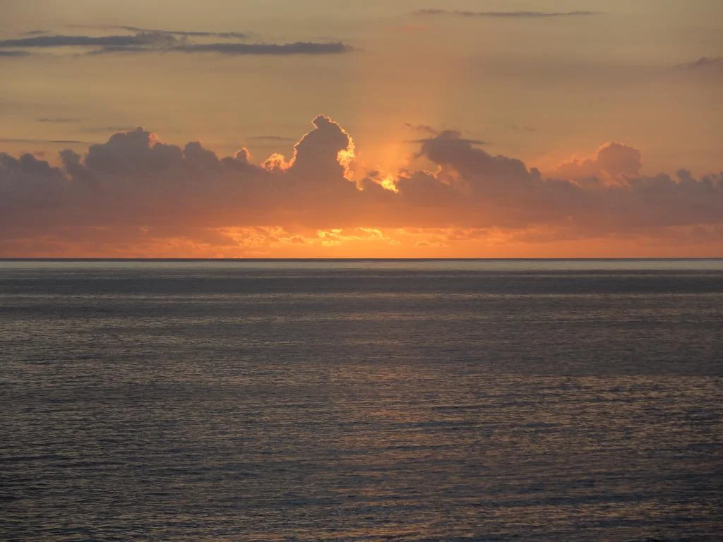
The west of Mauritius: the mountains, the lagoon, and the sun setting into the sea
 The essentials in a few words
The west stretches from Port-Louis to Le Morne. It is the driest and sunniest region of the island, sheltered from the trade winds by the terrain.
It includes the beaches of Flic en Flac, Wolmar, La Preneuse and Le Morne, Tamarin Bay and its dolphins, the Black River Gorges National Park with the highest point in Mauritius, the coloured lands and waterfalls of Chamarel, the Casela Wildlife Park, and the Le Morne Brabant mountain inscribed as a world heritage site.
It is also the only side of the island facing the setting sun. The capital, Port Louis, marks its northern boundary.
This is the only side of the island where you can see the sun set over the water. Elsewhere, it disappears behind a mountain or a sugarcane field; here, it dips straight down towards the horizon, facing the lagoon, and the late afternoon light shifts from gold to copper in just a few minutes. Mauritians know this: on Friday evenings, the beaches of the west coast fill up with families who come to watch.
The west is also the dry side. It's where the mountains plunge almost into the sea, where the vegetation in places resembles a savanna of thorny acacias, and where it's hot even when the central plateau is shrouded in clouds. Between Port Louis and Le Morne peninsula, you'll find the capital and its mountains, eight kilometers of sand at Flic en Flac, salt flats, a primary rainforest national park, colorful landscapes at an altitude of seven hundred meters, and a UNESCO World Heritage mountain that closes off the lagoon like a rampart. On an island of two thousand square kilometers, that's a lot for a single side.
Summary
- The west in brief: the dry, leeward slope
- Port Louis, the capital nestled against its mountains
- From albion To flic En Flac: the coast of beaches
- Tamarin, Rivière Noire and La Preneuse
- The heights of Chamarel
- The Black River Gorge and the island's roof
- Le Morne and the southwest point
- Sea trips and water sports
- Casela and the hinterland
- Practical tips for visiting the west
- Frequently Asked Questions about the west of Mauritius
- Photos
The west in brief: the dry, leeward slope
In Mauritius, the wind blows from the southeast almost all year round. It arrives laden with moisture, hits the central plateau, rises, cools, and loses its moisture over the higher ground. When it blows back down the other side, to the west, it has very little left. This is the whole principle of the leeward slope, and it's what gives this region its distinctive character.
The figures are spectacular. During the first two weeks of July 2026, the Mauritius Meteorological Services noted 1 mm of rain in the westThis represents 11% of the usual average, while the central plateau receives 57 mm over the same period. The episode was exceptionally dry, but the disparity is a constant: the same amount of rain does not fall on both sides of an island that can be crossed in an hour's drive. The central plateau can receive several times the rainfall of the west coast in a year.
This aridity is evident in the landscape. Where the east and south are lush and green, the west features patches of thorny acacia trees, dry grasses, and large columnar cacti growing along the edges of the paths. It feels like being in the African bush—an impression only heightened by Casela Park, with its zebras grazing in the shade of the thorny trees.
The terrain is another defining characteristic. This is where the island's highest mountains are found, and they don't stay far away: the Black River range descends right to the coast, and from any beach in the region, mountains are visible. From La Preneuse, the silhouette of Le Morne can be seen on the horizon, across the bay. From Le Morne, the entire coastline stretches northward. No other region of Mauritius plays so effectively on this contrast between the lagoon and the basalt cliffs.
To locate the west within the island as a whole, see the page geography of Mauritius provides the general framework, and the portrait of the north of Mauritius allows for comparison with the other major seaside region.
Port Louis, the capital nestled against its mountains
Port Louis closes off the west to the north. The city is built in an amphitheater of mountains that press it against its port — the Moka range on one side, Signal Mountain on the other — and this configuration explains almost everything about it: the heat that accumulates there, the density of its center, and the fact that it has developed lengthwise along the sea rather than spreading out.
It's not a seaside town and nobody comes here for the beach. People come for the central market and its aromas of spices, for the seafront of the Caudan Waterfront, for the view from the citadel, Fort Adelaide, which overlooks the rooftops and the harbor, or for the national museum of natural history and its reconstructed dodo. It is also the entry point for cruise passengers, including thestopover in Port Louis it all happens in one day.
The subject goes far beyond the scope of a regional portrait: the page dedicated to Port-Louis it treats the whole thing, district by district.
From albion To flic En Flac: the coast of beaches
South of the capital, the coastline relaxes. The suburbs give way to villages, then to a succession of beaches that make the west famous for its seaside reputation.
Albion and its lighthouse
Albion is a former fishing village, halfway between Port Louis and Flic en Flac. Its coastline alternates between golden sand and black volcanic rock sculpted by the waves, making it a unique place on this coast. Its emblem is the pointe aux Caves lighthouseCommissioned in 1910 and perched on the edge of a cliff riddled with sea caves, it is one of the few lighthouses on the island open to the public, and the view is particularly beautiful in the late afternoon.
Flic en Flac
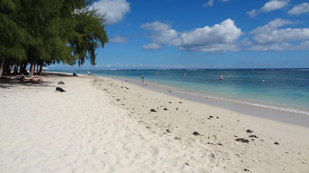
Flic en Flac it is the main seaside resort on the west coast, and its beach is one of the longest in Mauritius: several kilometers of sand lined with casuarina trees, with a shallow, calm lagoon. It's a very Mauritian place on weekends, where families arrive early with coolers and mats, and more touristy during the week.
One crucial detail, often overlooked but important when choosing accommodation, is that "being in Flic en Flac" doesn't necessarily mean being within walking distance of anything. The resort is sprawling, and depending on the exact location of a villa, you might find yourself unable to reach anything on foot—especially since not all the paths are lit at night. The question to ask before booking isn't "Is this in Flic en Flac?" but rather "What's within a five-minute walk, and how do you get there at night?"
A photo page of Flic en Flac completes the visit.
Wolmar
Immediately south of Flic en Flac, Wolmar it is a calmer extension of the same stretch of sand, where several hotels have been established. It is significantly less crowded, despite offering a lagoon of the same quality.
Tamarin, Rivière Noire and La Preneuse
Beyond Wolmar, the road leaves the straight line and begins to follow the contours of the coast. This is the most varied area in the west, and probably the least known to visitors.
Tamarin Bay and its salt flats
Tamarin is an open bay, where the river of the same name meets the sea. Its unique feature is that it is one of the few places in Mauritius where the swell enters the bay directly: it is the cradle of Mauritian surfing, and the atmosphere is more like a surfers' village than a seaside resort.
Just beyond, the Tamarin salt pans form a checkerboard of shallow basins where seawater evaporates in the sun. The activity is precisely what characterizes the region: without this dry climate and abundant sunshine, production would not be possible here. The basins are clearly visible from the road, and the landscape they create, with Rempart Mountain in the background, is one of the most photogenic in the west.
It is also from Tamarin that dolphin watching trips depart, as the dolphins come to rest in the morning in the calm waters of the bay.
The Taker and her martello Tower
The Taker it is a quiet public beach, very popular with Mauritians and much less so with tourists. The lagoon is shallow, the water a clear blue, and in the distance, on the other side of the bay, you can see the dark mass of Le Morne Brabant — a view that gives you a sense of the region at once.
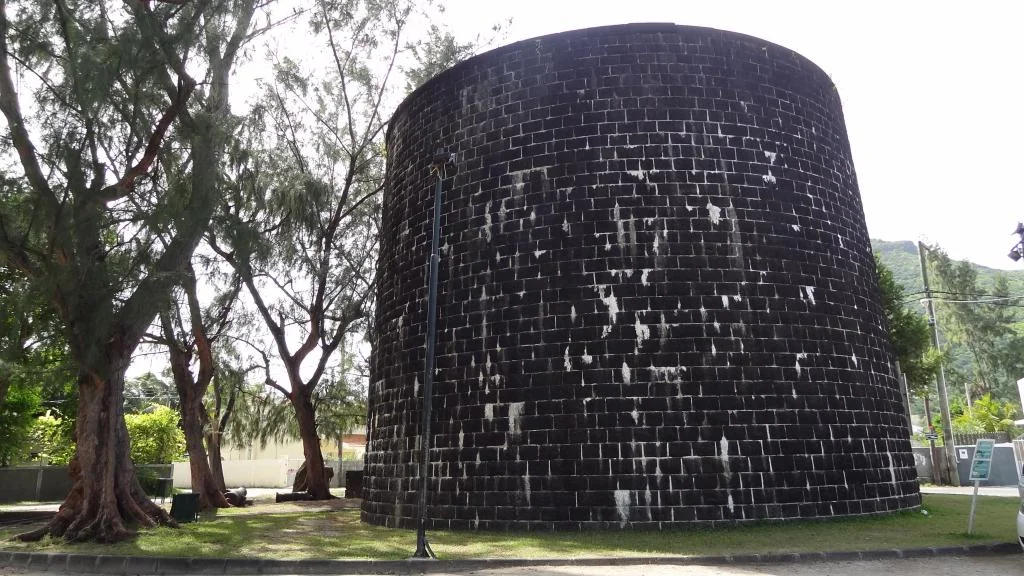
At the end of the beach stands the martello Tower, British military construction of the 19the century transformed into a museum. It is one of the few places on the island where you can concretely understand, by climbing the stairs and touching the walls, what coastal defense represented at the time.
Great Black River
The village of Grande Rivière Noire, further south, is the coastal access point to the national park. It is also the home port for a large number of the region's big game fishing boats and sea excursions.
The heights of Chamarel
The road that climbs to Chamarel leaves the coast at Case Noyale and ascends in tight switchbacks. In a few kilometers, you go from the lagoon to a plateau at more than three hundred meters altitude, cooler and much greener: you have changed worlds without changing regions.
The land of Seven colors
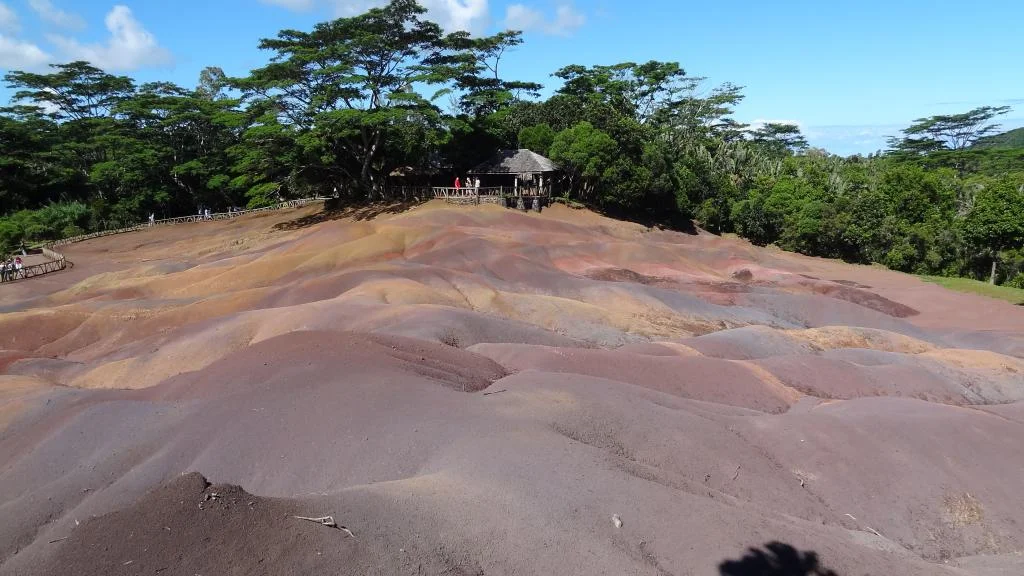
It's the most visited site in the west. Undulations of colored sand, ranging from red to purple, ochre, and blue, are illuminated by the changing light throughout the day. A single ticket grants access to the entire area, including the waterfall and the giant tortoises, making it a good half-day visit. Everything is detailed, including the geological explanation of the colors, on the website. land of 7 colors.
The Chamarel waterfall
There chamarel waterfall it plunges in a single cascade into a wooded cirque, and it is the highest waterfall on the island. The information panel installed on the site reads 100 meters highHe explains that the waterfall cuts through two lava flows of different ages: an initial flow between 10 and 8 million years old, which remained exposed to the air for so long that its surface turned to earth, later covered by a second flow between 3.5 and 1.7 million years old. The waterfall is therefore a cross-section of the island's volcanic history. It can be viewed from a specially designed platform, without any particular effort.
Chamarel's point of view
On the way up, the chamarel's point of view it opens onto the entire southwest coast, from the lagoon to Le Morne. It's a free and quick stop, often overlooked because it's not listed on any ticket.
The Black River Gorge and the island's roof
The Black River Gorges National Park protects the last large indigenous forest in Mauritius. According to the National Parks and Conservation ServiceIt covers 6,574 Hectares In the southwest of the island and is home to the country's highest point, the piton de la Petite Rivière Noire, at 828 metersIt was created on June 5, 1994 and is part of a biosphere reserve recognized by UNESCO since 1977.
What you see is a vast expanse of canopy plunging into deep ravines, with the ridges at the bottom and, on a clear day, the plain and the sea in the distance. The forest is the last refuge of several birds that exist nowhere else—the Mauritius kestrel, the pink pigeon, the echo parakeet—saved at the last minute from extinction.
You don't need to walk to enjoy it. This is the point that is missing from most pages devoted to the Park: the viewpoint of the Black River Gorges it's accessible by car; you park and the view is there. Many visitors give up on the park believing that you need a day of hiking to see anything; this is false.
For those who prefer hiking, the park offers a well-developed network of marked trails, with two information centers, one at Pétrin and the other at Grande Rivière Noire. The summit of the peak is most often reached from Plaine Champagne. See the page for... hiking in Mauritius.
Le Morne and the southwest point
You can see Le Morne Brabant long before you get there. It is a 556-meter basalt block that closes the southwestern tip of the island, isolated, almost vertical on its faces, and stands out on the lagoon in a way that nothing else in Mauritius can match.
A mountain classified because of what happened there
The Le Morne cultural landscape has been a UNESCO World Heritage Site since 2008, and it's important to emphasize that this is not for its beauty: it's for its history. The mountain's cliffs and caves served as a refuge for runaway slaves, who found an inaccessible haven there. Le Morne became a symbol of this resistance, and a memorial to the Slave Route stands at its base. The entire region, with its rugged terrain, played this role as a refuge—it's the same geography that produces the postcards and that allowed the runaways to survive.
Full details are available on the dedicated page. Morne Brabant.
Climb, even without going to the summit
A point that is rarely mentioned: you can do a good part of the climb up Le Morne without being an experienced hiker. The trail climbs steadily through the vegetation to a plateau, and it is here that the terrain becomes decidedly more difficult—beyond This point, the ascent is for experienced hikers only. However, the view is already fully present before this break In the terrain: the lagoon below, the dark patches of seagrass in the clear water, a wooded islet in the middle, the mangroves, and the reef line in The distance. one can therefore stop here without feeling like one has Missed anything. details and precautions are found on the [website/page name]. hiking up Le Morne Brabant.
Le Morne beach
There morne public beach it's a long ribbon of white sand lined with coconut palms, with the mountain just behind. The water is remarkably clear and slopes very gently upwards, so you have to walk for a long time before you can touch the bottom more than mid-calf. It's also from here that the boats depart and the catamarans are lined up on the sand.
La Gaulette and the Island of the Holy Water Sprites
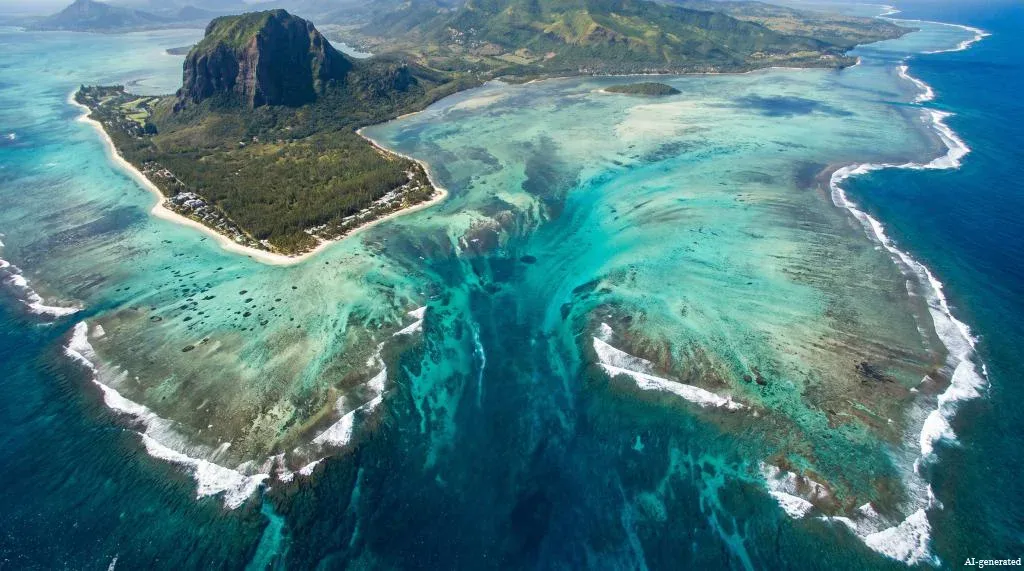
North of Le Morne, the village of La Gaulette is the starting point for thebénitiers Island, a flat islet covered in coconut palms in the lagoon. The excursion is usually combined with the underwater waterfall, this spectacular optical illusion visible only from the sky, off the coast of Le Morne.
Sea trips and water sports
The west concentrates a good part of the island's nautical activities, precisely because it is sheltered: the lagoon is calm there when the east is whipped by the trade winds.
Dolphins. Groups of dolphins come to rest every morning in Tamarin Bay and off Black River. Tours depart early, often before 7:00 AM. Please note: this activity is regulated by law, with distances to be respected, a limited number of boats, and penalties — the conditions are detailed on the page swimming with dolphins in Mauritius and in the guide to regulations on dolphin, turtle and whale watchingA Service provider who does not respect these rules is not a good service provider, regardless of their price.
Kitesurfing. The Morne lagoon is one of the most renowned spots in the world, with regular winds and a body of water that offers both flat water for beginners and waves for experienced surfers — including the famous One Eye left, reserved for experts.
Surfing. Tamarin remains the historical reference for Mauritian surfing, with a wave that only works under certain swell conditions.
Catamarans and big game fishing. Catamaran trips to Île aux Bénitiers depart from La Gaulette and Rivière Noire, and big game fishing is an old specialty of Rivière Noire, where the trench is close to the coast.
Casela and the hinterland
Moving away from the coast, the west becomes a plain of sugar cane rising towards the foothills of the Black River range, with Bambous as the capital and the commercial center of Cascavelle as the supply point.
That's where it is CaselaThe island's largest wildlife and adventure park. The entrance ticket grants access to the safari truck ride through an enclosure housing zebras, ostriches, and antelopes, the aviaries where you can walk among the birds, and the children's farm. Other activities are available for an additional fee, and some have strict conditions: walking with the lions is only open to visitors over 15 years old and at least 150 cm tall, and closed-toe shoes are required for most activities.
An honest observation about the park's evolution: Casela has added a lot of thrill rides in recent years—zip lines, quad bikes, buggies, roller coasters. These activities have little to do with the animals, and visitors coming for the wildlife don't need to spend a penny on them. The safari, aviaries, and petting zoo are enough to fill a day, and these are what make the place truly worthwhile. casela photo page gives an idea of the whole thing.
Casela is also where the dry vegetation of the west is best seen: paths lined with thorny acacias, yellowing grasses, and large columnar cacti. A turquoise lagoon is a fifteen-minute drive away, and you'd think you were in a completely different climate.
Practical tips for visiting the west
When to come. The west is the safest region of the island weather-wise, and this holds true year-round. During the southern winter, from May to October, it is sheltered from the trade winds that cool the east; in summer, it receives less rain than the rest of the island. The trade-off is the heat: from December to March, accommodation without air conditioning can become unbearable at night, especially in rentals. This is a question to ask before booking, not after. See the weather in Mauritius.
Move. The coastal road connects Port Louis to Le Morne and serves all the areas above; the M1 motorway and the Bambous road provide quick access to the plateau and the airport. car rental this remains the most comfortable option for this region, where interesting sites are scattered between the coast and the hills. the Roads up to Chamarel are narrow and winding, but in good condition.
Where to stay. The west offers accommodation at all levels, from village villas to the luxury hotel in Le Morne. The main choice is between the lively atmosphere of Flic en Flac, the tranquility of Tamarin and Rivière Noire, and the exclusivity of the southwest tip. (Pages) which coast to choose for your vacation? and choose your accommodation help to decide, and the booking a hotel or villa is done directly online.
A simple route. A day that works perfectly: the view of the gorges in the late morning, Chamarel and its colorful landscapes in the afternoon, a descent back to the coast via Case Noyale, and sunset on a west-facing beach — which is where you find the most beautiful sunsets in MauritiusAll the sites in the region are located on the map of tourist sites and activities.
Frequently Asked Questions about the west of Mauritius
What is the most beautiful beach on the west coast Of Mauritius?
Le Morne beach is generally considered the most spectacular in the west, thanks to its white sand, crystal-clear lagoon, and the mountain that overlooks it. Flic en Flac, on the other hand, offers the longest stretch of sand and the most amenities, while La Preneuse is the quietest of the three.
Is the west of Mauritius really drier than the rest of the island?
Yes. The west is the leeward side: the southeast trade winds release their moisture onto the central plateau before reaching this coast. The readings of Mauritius Meteorological Services regularly show very significant differences between the west and the plateau, up to several tens of millimeters over a single fortnight.
Do you have to hike to see the Black River Gorges?
No. The main viewpoint overlooking the gorge is accessible by car, with on-site parking and the view immediately available. Hiking trails exist and are marked, but they are an option, not a requirement.
Is it possible to climb Le Morne Brabant without being an experienced hiker?
You can climb to the plateau, where the view of the lagoon is already complete, provided you are in good general fitness and wear sturdy shoes. Beyond this point, the terrain becomes significantly more difficult, and the accompaniment of a guide is strongly recommended.
How many days does it take to visit the west of Mauritius?
Two full days are enough to see The essentials: one day for the Highlands (gorges, chamarel) and one day for the southwest Coast (Le Morne, La gaulette, boat trip). Including casela, Port Louis, and some beach time, you can easily fill four to five days.
Is the west suitable for a holiday with Children?
Yes, especially. The lagoons of Flic en Flac, Wolmar and Le Morne are shallow and calm, Casela is designed for families, and the distances between sites remain short.


The information in this article is provided for guidance purposes only. The author and publisher accept no responsibility for the accuracy of the information provided. It is recommended that you verify the information directly with local operators or the relevant Mauritian authorities during your stay. See the Terms (Article 12).
Last updated: August 2026
(The photos you send will only be used to complete this page and will never be used commercially outside of this site without your permission)
To share photos of your vacation in Mauritius with your friends, family and colleagues, we offer to create for you a personalized and free page dedicated to your stay. You will then just need to send the address of this page, for example www.ilemaurice-im/vacancesdepierreetmarie, to those with whom you wish to share your photos.
Nothing could be simpler, click on the button below.
Info +:
Rent a car
Book hotel or villa
Buy a plane ticket
7 day Weather forecast
Bus routes: Click here
Your advertising on this page?
Want to display an ad for your business on this particular page (or elsewhere on the site)?
Please contact us in click here.
Contribute, improve this page
We want to provide the most relevant and complete information to internet users, so if you want to add something or modify this page (text, Photo, etc.), Or even report an error, do not hesitate to contact us by sending us an email to the following Address: contribuer@ilemaurice.im
(remember to clearly indicate the page concerned by your contribution)
(the photos sent will only be used to complete this page and will never be used commercially outside of this site without your consent)