
Mauritius seen from space: photos of Sophie Adenot decrypted
 The essentials in a few words
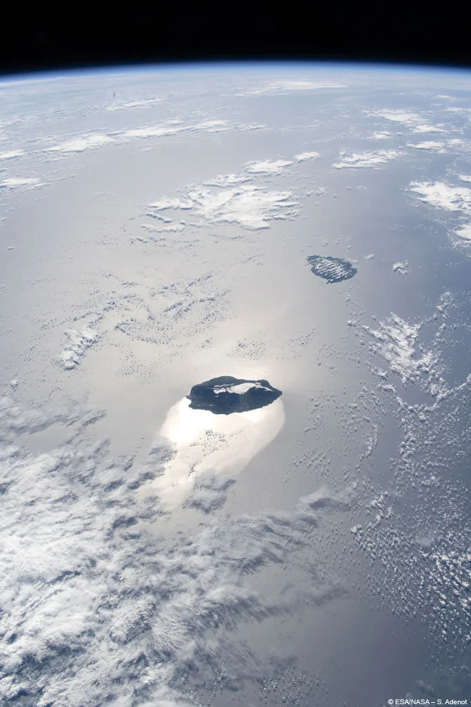
Seen from space, Mauritius appears as a compact green spot, streaked with cloud bands, lost in the deep blue of the Indian Ocean. The almost vertical perspective crushes the relief: we can see neither the mountains nor the famous lagoon in all its splendor, only a few bursts of turquoise on the edges. This image, taken by astronaut Sophie Adenot from the International Space Station, is not the most spectacular one could imagine, but it is sincere: it shows a small isolated volcanic island in the middle of the ocean, and reminds, on the occasion of World Oceans Day, how precious and fragile its marine environment is.
A green mass lying on the deep blue of the Indian Ocean, veined with long trails of clouds, with a few touches of turquoise where the coast surfaces: this is Mauritius as photographed by French astronaut Sophie Adenot from the International Space Station, some 400 kilometers above sea level. An image shared on the occasion of World Oceans Day, which offers a rare perspective on the destination.
This photo is not a slick postcard: it shows the island as it is actually seen from above, partly hidden by clouds, isolated in the middle of a vast sea. And that's precisely what makes it interesting. We invite you to decipher what we really see in this photo, and what it says about the geography and fragility of Mauritius. View the photo in large format.
Summary
- A photo signed Sophie Adenot
- What the photo really shows
- Reunion, the sister island
- Why does the island look so flat from above?
- Clouds, clues to hidden relief
- Deep blue and turquoise edging
- Admire Mauritius from above without leaving Earth
- What this image says about the fragility of the island
- frequently asked Questions
- Photos
A photo signed Sophie Adenot
Sophie Adenot is an engineer, helicopter pilot and astronaut with the European Space Agency (ESA). On a mission aboard the International Space Station since February 13, 2026, she regularly photographs the Earth from the station's observation dome, this glass post which offers a bird's eye view of the planet.
For World Oceans Day, she shared a series of photos of islands in the Indian Ocean, including Mauritius. Her message accompanying these images goes beyond aesthetics: protecting the ocean, she writes in substance, means preserving one of the essential pillars of the Earth system, at the same time a reservoir of biodiversity, a regulator of the climate and a link between the continents. Seen from space, she emphasized, there is only one ocean, truly global. It is in this spirit that we must look at this photo of Maurice.
What the photo really shows
Let's be honest about what we see, and what we don't see. The photo is not a postcard view of the lagoon: it is a documentary image, taken as you pass the station.
What we can clearly see:
- A green earth mass, compact and rounded, which occupies the center of the image.
- From wide bands of white clouds which block the island diagonally and hide a large part of it.
- A deep blue, almost marine ocean, all around, which indicates the great depth of the water offshore.
- A few touches of turquoise on the edges, where the sea becomes shallow near the coasts.
- From small islets scattered offshore, towards the north of the island.
What we don't see, contrary to what we might expect: no protruding mountains, no details of the beaches, no large identifiable tourist landmarks. The resolution, altitude and clouds do not allow this. This is an overview, not a zoom.
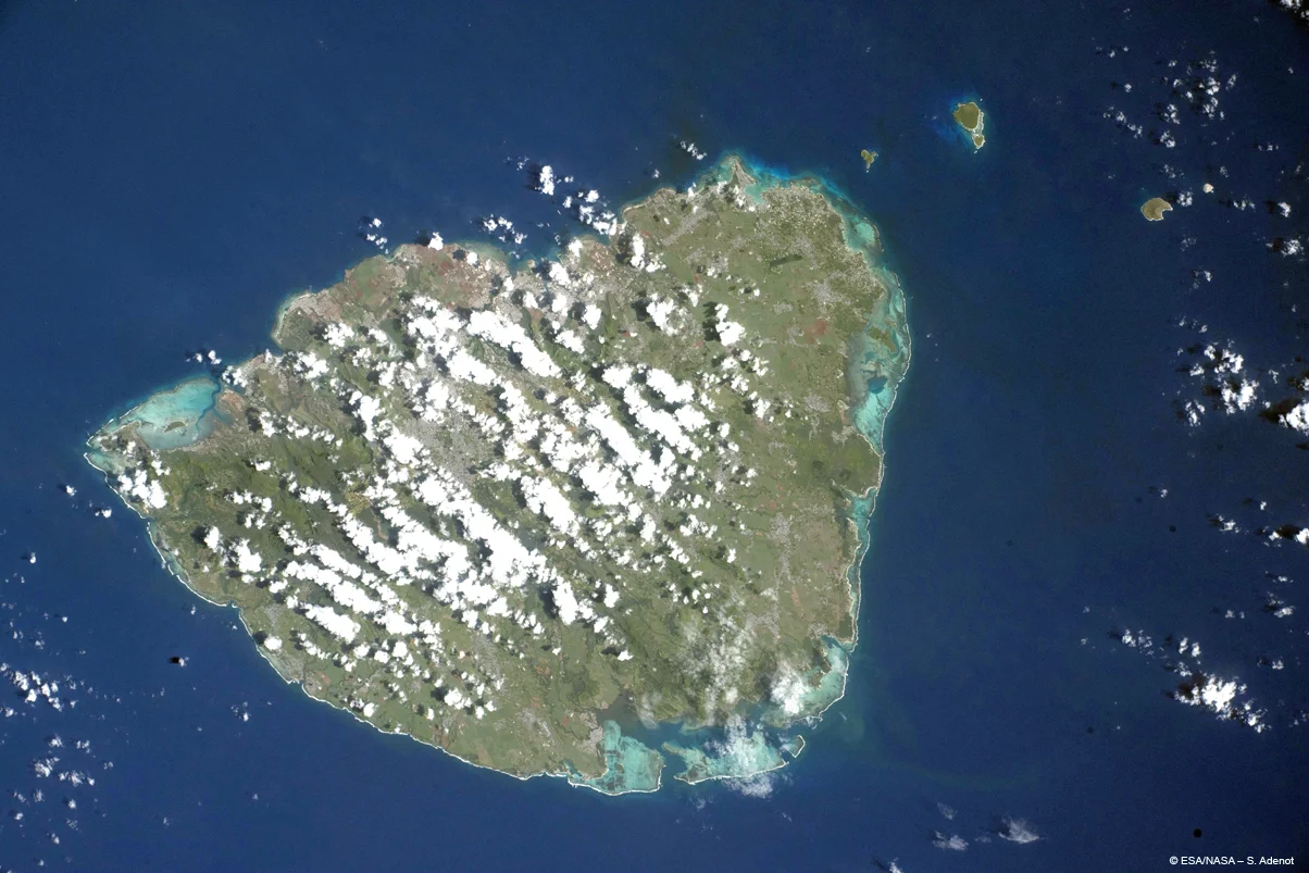
Reunion, the sister island
In the same series, Sophie Adenot shared a second photo, this time dedicated to Reunion Island, Maurice's neighbor. The two islands, approximately 230 kilometers apart, form what are often called the sister islands of the Indian Ocean and share, with Rodrigues, the Mascarene archipelago.
They are sisters by their origin: both were born from the same volcanic hot spot, rising from the bottom of the Indian Ocean. But they are not the same age or the same face. Réunion is the youngest and highest, dominated by the Piton des Neiges (over 3,000 meters) and the Piton de la Fournaise, one of the most active volcanoes on the planet; its relief is steep, almost alpine. Mauritius, older and more eroded, has a softer and rounded relief, and above all this wide belt of lagoons and coral reefs that Reunion, younger, almost does not have. In this second photo, we observe off the coast of Reunion Island a mirror effect on the surface of the water, the light of the sun reflecting there as if on ice - a phenomenon of specular reflection that she herself has commented on. To better understand what shapes Maurice, the geography of Mauritius worth a detour.
Why does the island look so flat from above?
This is undoubtedly the most surprising: in the photo, Maurice seems perfectly flat, like a green leaf placed on the water. But the island is anything but flat. It culminates at 828 meters at Piton de la Petite Rivière Noire and has many spectacularly shaped mountains.
The explanation lies in perspective. The photo is taken almost vertically, from an altitude of 400 kilometers. Seen from this angle, the relief is crushed: without marked shadows or profile view, the mountains do not stand out. It's the same effect as when you look at a mountain landscape on a satellite map: as long as you don't switch to an oblique view, everything appears flat. The volcanic relief of Mauritius is only really revealed on the ground or in a grazing view.
Clouds, clues to hidden relief
Paradoxically, it is the clouds which betray the invisible relief. The cloud bands are not distributed randomly: they form and hang above the heights of the island.
Mauritius was born from the activity of a volcanic hot spot under the Indian Ocean, several million years ago, within the Mascarene archipelago which it shares with Reunion and Rodrigues. The island is actually the emerged summit of an underwater volcano, now extinct. In his heart rises a central tray, cooler and more humid, which forces the moisture-laden air to rise and form these clouds. When we see these white streaks in the photo, we are looking, indirectly, at the imprint of the relief and climate of the interior of the island. The clearest witness to this volcanic past remains the Trou aux Cerfs crater, above Curepipe.
Deep blue and turquoise edging
The contrast between the very dark blue of the open sea and the rare flashes of turquoise near the coast also tells a story of depth.
Far from land, the ocean plunges very quickly to several hundred, even thousands of meters. The water there absorbs light and appears a deep blue, almost black. Near the coast, where the sea is only a few meters deep on a bed of light coral sand, the light is reflected and the water takes on these turquoise hues. In the photo, this turquoise only appears in places, where the clouds do not obscure the shore. On the ground, however, this border becomes the famous Mauritian lagoon, protected on a large part of the coast by a coral reef — an ecosystem on which all the beauty of these waters depends.
Admire Mauritius from above without leaving Earth
No need to go into space to gain height on the island. Several options allow you to take a look at it, and appreciate, this time, all the relief.
- Viewpoints at altitude. The Chamarel belvedere and Black River Gorges National Park dominate the southwest. From the edge of Deer hole, the circular view embraces a large portion of the island.
- Hiking. Theascent of Morne Brabant, to the southwest, rewards the effort with a bird's eye view of the lagoon - the oblique angle that the spatial photo lacks.
- The plane window. This is undoubtedly the simplest, and free, way to see Mauritius from above: upon arrival and take-off, and during the day, the porthole offers a striking view of the terrain, the lagoon and the coral reef. Le Morne, the mountains of the southwest and the cane fields are then revealed from an angle that we will not forget. A good reflex: reserve a window seat and keep the camera within reach during the approach.
- Flyover and drone. Photographing the island from the air is possible, but within limits: before flying a camera, consult the drone regulation in Mauritius, which imposes strict rules depending on the areas.
And after having taken in the island with a single glance, the most beautiful thing remains to be done: explore it region by region, from North animated at South wild, of theis and its lagoonsWhere is sunny, without forgetting the center and its heights.
What this image says about the fragility of the island
If Sophie Adenot shared this photo for World Oceans Day, it is for her message. Seen from space, Mauritius is just a small point of land surrounded by water on all sides: an oceanic island whose life depends entirely on the health of the sea that surrounds it.
This balance is fragile. Warming oceans cause coral bleaching, a phenomenon where coral, stressed by too warm waters, expels the algae that nourish and color it, then bleaches and risks dying. However, it is this reef that creates the lagoon, breaks the swell, protects the coasts and shelters marine life. Rising sea levels, another consequence of climate change, are adding pressure on low-lying coastlines and beaches.
At their own level, visitors can help preserve this fragile balance: do not touch or trample the corals when snorkeling, respect the instructions in protected areas such as the marine park of Blue Bay, and choose responsible service providers forwhale watching or swimming with dolphins. When the reef is doing well, it announces it every year with a striking spectacle: the spawning of corals which tints the sea pink. To prepare for a responsible discovery of the island, the complete guide to Mauritius brings together the essential things to know.
frequently asked Questions
Who photographed Mauritius from space?
Sophie Adenot, French astronaut from the European Space Agency, on a mission aboard the International Space Station since February 13, 2026. She shared in June 2026, for World Oceans Day, a photo bringing together Mauritius and Reunion Island, in order to raise awareness of the fragility of the oceans.
Why does Mauritius appear flat in the photo taken from space?
Because of the perspective. The photo is taken almost vertically from an altitude of 400 kilometers: without a profile view or marked shadows, the relief is visually crushed. In reality, Mauritius is a mountainous volcanic island that rises to 828 meters.
Why do we see so many clouds on the island?
The clouds cling to the central plateau of the island, which is higher, cooler and wetter. The air laden with humidity rises there and forms these cloud bands. They thus betray, indirectly, the relief that the vertical perspective does not show.
Why is the water turquoise in places and dark blue in others?
It's a question of depth. Near the coast, the shallow water with a bottom of light coral sand reflects the light and appears turquoise. Offshore, the ocean plunges several hundred meters: it absorbs the light and takes on a deep, almost marine blue.
Can you see Mauritius from above without going into space?
Yes. Several viewpoints offer a high-altitude panorama, such as the Chamarel belvedere, the Rivière Noire gorges or the Trou aux Cerfs crater. The ascent of Morne Brabant gives a bird's eye view of the lagoon. For a drone flight, local regulations must be respected.
Photos: Mauritius and Reunion seen from the International Space Station. Credit : ESA/NASA – S. Adenot. Images shared on the occasion of World Oceans Day.
The information in this article is given for information purposes only. The author and publisher assume no responsibility for the accuracy of the information mentioned. It is recommended to verify information directly with local operators or the relevant Mauritian authorities during your stay. See the Terms (Article 12).
(The photos you send will only be used to complete this page and will never be used commercially outside of this site without your permission)
To share photos of your vacation in Mauritius with your friends, family and colleagues, we offer to create for you a personalized and free page dedicated to your stay. You will then just need to send the address of this page, for example www.ilemaurice-im/vacancesdepierreetmarie, to those with whom you wish to share your photos.
Nothing could be simpler, click on the button below.
Info +:
Rent a car
Book hotel or villa
Buy a plane ticket
paying
7 day weather forecast
Walk and hike
Accessible child and stroller
Wheelchair accessible
Parking
Public toilets
Fast food outside
Bus routes: Click here
Your advertising on this page?
Want to display an ad for your business on this particular page (or elsewhere on the site)?
Please contact us in click here.
Contribute, improve this page
We want to provide the most relevant and complete information to Internet users, so if you want to add something or modify this page (text, photo, etc.), or even report an error, do not hesitate to contact us by sending us an email to the following address: contribute@ilemaurice.im
(remember to clearly indicate the page concerned by your contribution)
(the photos sent will only be used to complete this page and will never be used commercially outside of this site without your consent)