
The Natural Bridge
The Natural Bridge: a lava arch over the Indian Ocean
 The essentials in a few words
The Natural Bridge is a basalt arch carved by the ocean, on the south coast of Mauritius, in the Grand Port district.
People come here to see one thing and one thing only: the open sea rushing under the rock and exploding against the cliff, in a completely mineral setting.
Access is free, open, without schedules or facilities, but it is earned — the last few kilometers are on a dirt track through cane fields, then on foot.
Swimming is not allowed there, and the place has already claimed the lives of visitors.
Allow about an hour on site, to be combined with other sites in the wild south.
First, you have to leave the tarmac. The road ends, the track begins between the sugarcane fields, and for a few kilometers you sincerely wonder if you've missed a turn. Then the sugarcane fields part, the earth turns black, and the ocean is there—without a beach, without a lagoon, without anything to cushion its impact. On this coast, the sea reaches you in its entirety.
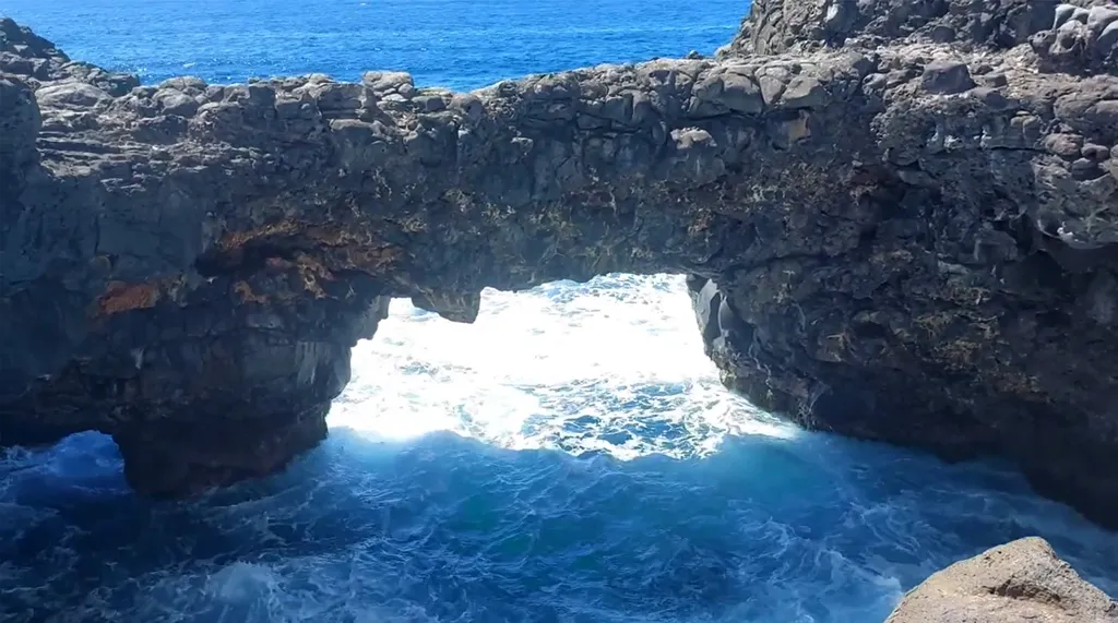
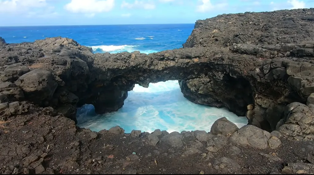
The Natural Bridge lies at the end of this track: a dark rock arch, spanning from one cliff lip to the other, beneath which the water swirls pale turquoise before receding. Beyond, the white line of the breakers marks where the southern swell crashes against the shore. There is no ticket booth, no barrier, no sign. Just a piece of lava pierced by the ocean, and the sound it makes as it flows beneath.
Summary
- A lava arch resting above the ocean
- Here, the sea is not held back by any reef
- How is a natural bridge formed?
- A rock from the hotspot
- Two meters or ten? That's what the sources say.
- Getting there: the track, the vehicle, the parking
- The real danger of the place
- When to go
- Around the Natural Bridge
- Frequently asked questions about Natural Bridges
- Photos
A lava arch resting above the ocean
The arch connects two promontories of volcanic rock separated by a notch in the shoreline. Seen from land, it appears suddenly, almost at eye level: a thick, irregular band of black stone, beneath which the water can be seen moving. There is no indication that one is approaching. The ground itself is a jumble of dark blocks, rounded by the surf, on which one must place one's feet with care.
What's striking is the contrast. The rock is almost black, matte, and porous. The water flowing beneath it is a milky turquoise, churned with foam, and changes color with each wave: deep blue when the swell arrives, opaque white when it recedes. A few hundred meters offshore, a continuous white line marks the breaking sea even before reaching the shore.
There is no sand, no shade, no amenities. No kiosk, no bin, no guardrails. It's a raw site, in the strictest sense: nobody takes care of it.
Here, the sea is held back by no barrier
On this section of the south coast, between Le Bouchon and SouillacThe coral reef that encircles most of the island is broken. This is the most important fact to understand before coming, and it explains everything else.
Elsewhere in Mauritius, the reef breaks the swell several hundred meters from the shore, leaving behind a shallow, calm, warm lagoon — the one of postcards and Blue BayHere, nothing of the sort. The swell formed in the southern Indian Ocean arrives unimpeded and hits the lava directly. Hence the spray, the noise, the suspended humidity, and the total impossibility of entering the water.
This is also what gives this entire coast its character: low cliffs, bare rock, sparse vegetation flattened by the wind. It can be found at Grey-Grey and at macondé's point of viewThe Natural Bridge is its most concentrated expression.
How is a natural bridge formed?
A marine arch forms in stages, not all at once. The wave first attacks the cliff at its base, where the rock is most fractured. It carves out a cavity, then a cave, by exploiting areas of least resistance: cooling joints, gas bubbles frozen in the lava, softer passages between two flows.
The cave sinks, widens, and eventually breaks through to the other side of the rocky outcrop or has its vault partially collapse. What remains above the void is the bridge. The sources that describe the Natural Bridge as "carved by the waves" and those that speak of "the collapse of a sea cave" are therefore not contradictory: they describe two moments of the same process.
This process doesn't stop. A marine arch is a form of transition, not a stable state: the sea continues to erode its supports, and all eventually collapse. When this will happen, no one here can say—no study focuses specifically on this site.
A rock from the hotspot
The lava of the Natural Bridge comes from the same mechanism that made the entire island. Mauritius was born above the hotspot of Reunion Island, a plume of hot material rising from the Earth's mantle, the same one that feeds the Piton de la Fournaise today and which, about 65 million years ago, produced the gigantic Deccan flows in India.
Geologists distinguish three major periods of volcanic activity on the island, separated by long periods of inactivity. The oldest series, between approximately 8.9 and 4.7 million years ago, built the volcanic shield, of which only the indented reliefs of the interior remain today. The middle series, between 3.5 and 1.66 million years ago, and then the most recent series, from about one million years ago to just a few tens of thousands of years ago, correspond to periods of renewed activity. It is the olivine basalts of this last phase that cover most of the island's coastal plains.
Two consequences for the visitor. First, the black, bubbly rock they are walking on is geologically very young. Second—and published works on the subject emphasize this—Mauritian volcanism is not considered definitively extinct: future eruptions remain possible, even if no activity is observed on a human timescale. The crater of Deer HoleIn Curepipe, the most visible example is this. For the general context, see our page on the geography of Mauritius.
On the other hand, we do not know to which of these three series precisely the flow of the Natural Bridge belongs: no source consulted specifies this, and we prefer to say so rather than decide by guesswork.
Getting there: the track, the vehicle, the parking
Access to the Natural Bridge is free and open at all times, but there is no public transport, no designated parking, and no reliable road signs. This is the biggest deterrent for visitors, and it must be taken seriously.
By car
The site is located in the Grand Port district, about fifteen kilometers from MahébourgIn the Carreau d'Accacia area. The most commonly described route passes through the village of Trois Boutiques, on the road to L'Escalier: leave the main road, drive until the end of the paved section, then take the dirt track that leads between the sugarcane fields to a small clearing where you park. The last few meters are on foot.
We provide this route as described by visitors, not as official information: descriptions vary from one source to another, the tracks change depending on the sugar cane harvest, and the signage, when it exists, is limited to a few markings painted on stones. Be prepared to do some searching and backtrack at least once.
Opinions also differ regarding the vehicle. A 4x4 or pickup truck can go almost anywhere and remains the most comfortable choice. Several visitors reported driving slowly in a small rental car on dry ground. However, after rain, the track becomes significantly less accessible for a low-clearance vehicle. If you're unsure, our guide to car rental in Mauritius details the available categories and what insurance actually covers in case of damage on the track.
On foot from Le Bouchon
There is an alternative for those who don't want to drive on the track: take the paved road to Bouchon beach, park there, and walk along the coast. Allow about thirty minutes for the walk on rocky and uneven terrain, with no shade. Good closed-toe shoes are essential—the lava is sharp and the boulders shift.
On an organized excursion
The Natural Bridge is included in the itinerary of several quad bike or 4x4 excursions that explore the wild south. It's the simplest solution if you don't have a suitable vehicle, and it also solves the question of route planning.
The site is also reported on our tourist map of Mauritius, which allows it to be situated in relation to other points of interest in the south.
The real danger of the place
The Natural Bridge is a dangerous place, and it has already claimed lives. This is not an editorial precaution: two drownings are documented there by the Mauritian press.
In April 2017, a 55-year-old man, out on a family outing, fell into the sea while taking photographs. The rough seas swept him out to sea. Despite the intervention of the coast guard and a rescue by police helicopter, he died shortly after being admitted to the hospital. The autopsy concluded that he died of asphyxiation by drowning. In December 2025, the body of a 54-year-old man was recovered from the same spot; he was already dead when rescuers arrived.
The risk factors remain the same. The volcanic rock is slippery where it's wet from sea spray, and it's constantly slippery near the arch. The swell is erratic: a series of small waves can be followed without warning by a significantly larger one that sweeps across the platform. Finally, once in the water, there's no beach, no lagoon, no foothold to climb back up—only a wall of lava and a current that pulls you out to sea.
Three concrete rules:
- Do not step on the arch. Many photographs seen online show visitors standing on it, sometimes newlyweds during a photo shoot. This is precisely the gesture that cost one of the victims their life, and the arch has no border.
- Stay away from the moisture line on the rock. It indicates how high the waves have risen recently, and therefore how high they will rise again.
- Never turn your back on the sea, in particular for posing or framing a photo.
There is obviously no first aid station, no lifeguard, and no swimming is possible at any time of year. The site is isolated, and cell phone coverage is not guaranteed. If you are coming with young children, hold their hands as soon as you get out of the vehicle.
When to go
Morning is the best time: the light comes from the east and illuminates the arch head-on, the air is more stable, and you'll have the site to yourself. Late in the day, the rock is backlit, creating silhouettes but little color on the water.
In terms of season, the austral winter, from May to September, brings the strongest swells and therefore the most impressive spectacle—but it's also the riskiest time to approach the shore. The austral summer is calmer at sea, warmer and more humid, with a risk of heavy rain that makes the track difficult. See our page on the weather in Mauritius before leaving, and simply give up if there is a high swell warning or cyclone warning.
Also avoid arriving in the late afternoon: the track is difficult to travel after dark, and there is no lighting.
Around the Natural Bridge
The Natural Bridge can be visited in less than an hour. No one makes the trip just for it: it's part of a day spent exploring the wild south.
To the east, Mahébourg and the lagoon of Blue Bay offer the exact opposite of what you just saw: calm, clear water, protected by the reef, where swimming is possible. Our mahébourg – Blue Bay Circuit details this part of the coast.
To the west, the reef-free coastline continues until... Souillac and to the cliffs of Grey-Grey, where we find the same confrontation between lava and the ocean, with the added bonus of a short hike to the Weeping RockFurther still, the macondé's point of view overlooks a lagoon with striking colours.
To put everything in context, our portrait of south of Mauritius compare these sites in relation to each other.
Frequently asked questions about Natural Bridges
Is there a fee to access the Natural Bridge?
No. Access to The Natural bridge is completely free and open, without tickets, opening hours, or a warden. The site is neither fenced nor developed.
Is it safe to swim there?
No, absolutely not. the Coral reef is interrupted on this stretch of coast: the swell From the open sea hits the rocks directly, and there is no access to the water or way to get back Out. to swim in this area, go to Blue Bay.
Do you need a 4x4 to get there?
It's not essential in dry weather, but it's significantly more comfortable. The last few kilometers are on a dirt track through sugarcane fields. After rain, a low-clearance vehicle is strongly discouraged. The alternative is to park at Bouchon beach and walk along the coast for about thirty minutes.
Can we walk on the ark?
It is physically possible and we strongly advise against it. The rock is slippery, the arch is unprotected, and a fall at this spot is potentially fatal: two drownings have been documented there, one of which occurred while the victim was taking photographs.
How much time should I allow for the stay?
Thirty minutes to an hour is more than enough time to explore the site and take photographs. However, allow extra time for the approach: between finding the trail and the final walk, the round trip from the main road easily takes an extra hour.
Is the Natural Bridge accessible to people with reduced mobility?
No. The terrain consists of irregular and unstable lava blocks, with no marked paths, and the final approach is on foot over rough ground.
What is the best time to photograph the Natural Bridge?
In the morning, the sun illuminates the arch from the front, highlighting the contrast between the black rock and the turquoise water. At the end of the day, the site is backlit.
Are there any amenities on site?
None. No toilets, no water fountain, no food service, no shade, and no trash cans. Bring water and sunscreen, and take your rubbish with you.
The information in this article is for guidance only. The Natural Bridge is an undeveloped, unsupervised natural site that presents a real danger: fatal drownings have occurred there. The author and publisher accept no responsibility for the accuracy of the information provided or for the consequences of a visit. Before going there, check the sea conditions and current warnings with the Mauritius Meteorological Services and, if in doubt about access, with local operators. In case of emergency in Mauritius, dial 999 (police) or 114 (SAMU - Emergency Medical Services). See the Terms of Use (Article 12).
(The photos you send will only be used to complete this page and will never be used commercially outside of this site without your permission)
To share your Mauritius vacation photos with friends, family, and colleagues, we offer a free, personalized webpage dedicated to your trip. Simply share the webpage address, for example, www.ilemaurice-im/vacancesdepierreetmarie, with anyone you'd like to share your photos with.
It's very simple, just click on the button below.
More information:
7-day weather forecast
Rent a car
Book a hotel or villa
Buy an airplane ticket
Free
Walking and hiking
Child-friendly, no stroller required
Bus routes: Click here
Your advertisement on this page?
Do you want to display an advertisement for your business on this particular Page (or elsewhere on the Site)?
Thank you for contacting us in clicking here.
Contribute to and improve this page
We want to provide internet users with the most relevant and complete information, so if you would like to add to or modify this page (text, photo, etc.), or even report an error, please do not hesitate to contact us by sending an email to the following address: contribuer@ilemaurice.im
(remember to clearly indicate the page to which your contribution relates)
(The photos you send will only be used to complete this page and will never be used commercially outside of this site without your permission)
Not yet tested by the editorial team
If you would like to tell us about this place, this activity, etc., please send us an email to the following address: visiter@ilemaurice.im