
Furnace Island
Fourneau Island, the forgotten island at the foot of Le Morne Brabant
 The essentials in a few words
Fourneau Islet is a small wooded islet in the Morne lagoon, on the southwest coast of Mauritius, about 600 meters from the shore, opposite the village of Morne and south of the Morne Brabant mountain.
It is open to the public. The usual access is by boat, from the jetty in the village of Le Morne. The Mauritian press and accounts from visitors also describe a crossing on foot at low tide, following a line of light sand visible in the lagoon: this is neither an official route nor a supervised path, and it depends entirely on the conditions of the day.
There is a sandy beach, vegetation, a frontal view of Le Morne Brabant and a shallow lagoon ideal for swimming and snorkeling.
Day trips there include lunches of seafood prepared on site.
The place is steeped in history: the inhabitants of the old village of Trou Chenille used to come here to draw fresh water, and the islet is now located in the buffer zone of the Morne Cultural Landscape, a UNESCO World Heritage Site.
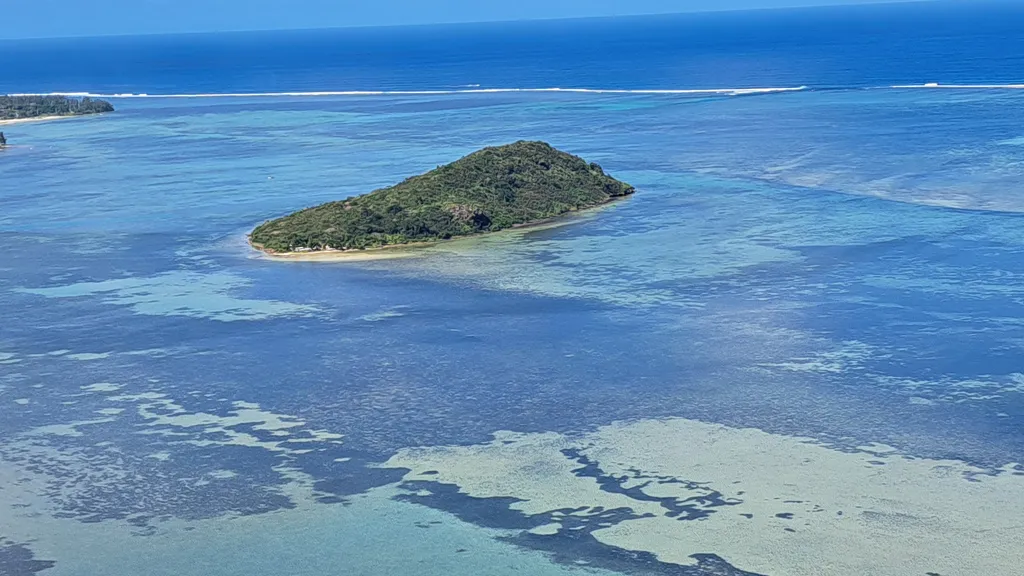
There's an islet in the Le Morne lagoon. You can see it from everywhere, yet almost no one knows its name. A green mound rising from the turquoise water, six hundred meters from the shore, between the village of Le Morne and the coral reef: Îlot Fourneau. It has a small sandy beach, a ring of trees, and a history that the neighboring mountain has ultimately overshadowed—the story of a village that used to cross the lagoon by dugout canoe to fetch its fresh water.
It's also one of the few islets in Mauritius said to be accessible without a boat. At low tide, when the lagoon empties and reveals the sandbanks, a clear line is drawn in the water from the coast of Le Morne: the Mauritian press and visitors' accounts describe the crossing on foot, with Le Morne Brabant behind you and the ocean roaring over the reef ahead. Five hundred meters of water, barely more, separate the islet from the nearest shore. The rest of the time, you go by boat from the village jetty, often to have lunch with your feet in the sand. In both cases, you disembark on a piece of world heritage that brochures haven't yet discovered.
Summary
An islet situated in the middle of the Morne lagoon
Fourneau Islet lies south of Le Morne Brabant mountain, in the large lagoon that stretches between the peninsula and the coral reef. The Le Morne Heritage Fund places the islet approximately 600 meters from the shore. It faces the village of Le Morne, whose jetty is the usual departure point for boats.
Seen from above, from the heights of Le Morne, the layout is immediately clear: the coastline and its river mouths to the left, the long stretch of clear water dotted with sandbanks and dark patches of coral, the islet in the middle like a green pebble, then the white line of the reef and the deep blue of the ocean beyond. This configuration explains everything else—the shallow depth, the walkable access, the color of the water, the calm of the lagoon that has made it one of the most famous kitesurfing spots in the world.

The islet is wooded up to the top of its small hill and bordered, on the lagoon side, by a sandy beach. It is uninhabited.
This lagoon is also a space for work and sport: kitesurfing schools are located on the tip of Le Morne, facing the islet, and the village fishermen go out there every day. It's not an empty landscape.
The island that provided water to the village of Trou Chenille
The true story of Îlot Fourneau is not maritime, it is domestic: it is the story of water. According to the documentation of the Morne Heritage Fund, many villagers recounted that they used to go by boat to Îlot Fourneau to draw water from a freshwater spring.
These villagers were from Trou Chenille, a village nestled at the southern foot of the mountain, facing the sea and the islet. According to testimonies gathered, Trou Chenille comprised about fifty huts, a shop, and a chapel. Water was obtained from natural springs and from Fourneau Island. The inhabitants were largely descendants of slaves, settled there after the abolition of slavery in 1835.
The village no longer exists. When the 1945 cyclone destroyed the thatched huts, the landowner of Le Morne relocated the population to L'Embrasure and the surrounding area of the mountain, and later, to the present-day site of Le Morne village. The shop and chapel were moved first, followed by the inhabitants. An open-air museum, the Trou Chenille Open Air Museum, now occupies the site of the vanished village, at the entrance to the mountain trail.
The question remains: is there still a spring on the islet? The available sources mention a freshwater spring in the past, within the context of Le Morne's oral history. None of them say what the situation is today, and we prefer to write it down rather than make a definitive judgment.
A British military post — with a date that raises questions
The same heritage documentation indicates that archives report the use of the islet as a military post by the British authorities in the 18th and 19th centuries.
This statement should be treated with caution on one point: The british Did not take Mauritius until 1810. A british military occupation of the island In the 18th century is therefore difficult to reconcile with the island's Chronology. it could be an inaccuracy in the wording, or a prior practice under the french flag later adopted By The british. based on current public sources, the exact nature and date of this military post are not established.
And the name?
We found no reliable source explaining the origin of the name "Fourneau." Several theories circulate in conversation, but none are documented. We won't repeat them: a blank slate is better than a neatly invented explanation.
An island in the buffer zone of a world heritage site
Fourneau Island is not just a pebble in the lagoon: it lies within the protected perimeter of the Morne Cultural Landscape, which was listed as a UNESCO World Heritage Site in 2008 as a memorial to maroonage and resistance to slavery.
The boundaries of the protected area need to be understood, as they are often misinterpreted. The inscribed property itself, the core area, comprises the mountain and its foothills, totaling approximately 349 hectares. Surrounding it, the buffer zone covers approximately 2,407 hectares and, according to the 2008 ICOMOS assessment report, encompasses the rest of the peninsula and the surrounding lagoons up to the coral reef. The islet, located within this lagoon, is therefore situated in the buffer zone, not in the core area.
This is not a mere administrative distinction without consequence. ICOMOS noted that more than half of this buffer zone is a marine environment and recommended that conservation and monitoring measures be extended to this marine environment, which was deemed neglected in the initial management plan. Furthermore, regulations adopted in 2006 under the National Heritage Fund Act delineated the Morne area, including the buffer zone.
In practical terms, for the visitor: you walk, you swim, and you disembark in a protected area where the coral, the sand, and the tranquility are all protected. This is reason enough to take nothing, leave nothing, and not trample the living coral.
How to get to Fourneau Island
There are two ways to get there: by boat, or on foot at low tide. The islet is open to the public.
By boat from the jetty of the village of Le Morne
This is the easiest and most common access. Boarding takes place at the jetty in the village of Le Morne, and the crossing is short. Several day trips to the southwest of the island include a stop at the islet with a seafood lunch prepared on-site, free time on the beach, swimming in the lagoon, and sometimes paddle boats; these packages are offered by private operators, with varying itineraries and prices. Fishermen and boat owners from the village also provide transfers.
Book or arrange the transfer in advance, and make sure you specify the Return time: there is no regular shuttle service.
On foot, at low tide
This is what makes Fourneau Island unique in Mauritius, and it's also the point on which we must be precise. What is established: the islet is separated from the nearest coast by approximately five hundred meters of lagoon, and the Mauritian press, as well as detailed accounts from visitors, describe a crossing on foot at low tide, following a clearly visible line of light-colored sand in the water. What is not established: no authority marks, measures, or recommends this route. The actual water depth along the route is not documented by any official source.
The crossing is made with Le Morne Brabant behind you and the ocean breaking on the reef ahead: the sensation of walking in the middle of the lagoon is what all accounts remember first. It is prepared like a sea voyage, not like a beach stroll.
Here are a few points that visitors' accounts repeat, and which should be taken Seriously:
- Closed shoes are essential. The seabed alternates between sand, coral, and sea urchins. The line of light-colored sand serves both to protect your feet and to prevent you from stepping on the coral.
- There is no shade on the route. Hat, t-shirt, water: The crossing is made in full sun, in water that does not cool you down.
- The water level varies according to the tides. According to accounts, at average low tide, the water generally remains below one meter along the route. This is not guaranteed: the water depth depends on the tidal coefficient, the wind, and the swell of the day.
- The return trip is planned before departure. The sea is coming in, and it's coming in everywhere at once. Leave at the beginning of the outgoing tide rather than at slack tide, and set yourself a return time.
This is not a marked hiking trail or an official route: there are no signs, no supervision, and no rescue services on site. In rough seas, strong winds, or if there is a swell warning, the hike should be abandoned.
Where to check tide times
Tide predictions for Mauritius are published by the mauritian meteorological services, which also give the times of high and low tides daily forecast bulletin in FrenchThis is the source to consult the day before and the morning of, along with the sea conditions and warnings of heavy swells.
What you can find there, and what you can't find there
A sandy beach on the lagoon side, vegetation, shade under the trees once you disembark, shallow and clear water for swimming and mask and snorkelAnd the view: the entire Morne Brabant, straight ahead, with the village at its foot.
What there isn't: no shop, no snack bar, no toilets, no drinking water, no trash cans, and no first aid station. What you bring, you take back—including your trash. Lunches served on the islet are brought and prepared by the tour operators; apart from these options, there is nothing.
The best time is in the morning, before the wind picks up: this is also when the lagoon is clearest, making it the safest time to cross on foot and the most beautiful for photography. The islet blends easily with the rest of the peninsula. the public beach of Le Morne, the Morne Brabant hike and its summit or the mountain itself and its historyYou Can locate the islet and other places in the southwest on our map of tourist sites and activities, and compare it to other islands and islets of Mauritius — starting with the island of the Holy Water Sprites, its neighbor in the same lagoon, much more frequented.
Frequently Asked Questions
Can we go to Fourneau island Freely?
Yes, the islet is open to The public. there are no ticket offices Or set times: access depends solely on the boat you find, or the tide if you go on foot.
Can we really walk there?
The crossing at low tide, following the line of light-colored sand visible in the lagoon from the coast of Le Morne, is described by the Mauritian press and by visitors. No official source confirms it, and there is no guarantee that it will be passable on the day of your visit: everything depends on the tide, wind, and swell. It is not a marked trail—no signage, no supervision, and no rescue services. Closed-toe shoes are mandatory, a return time must be set before setting out, and you should turn back without hesitation if the sea is rough. If in doubt, take a boat.
How long does the crossing take on foot?
The islet is about 600 meters from the shore, but the time it takes depends entirely on the seabed, the water level, and the route you take to avoid the coral. Allow plenty of time, and don't time your return trip too precisely.
Where do we embark to go there by boat?
At the jetty in the village Of Le morne. this is the starting point for excursions and transfers provided by local boatmen.
Is there a restaurant on the Islet?
No. Lunches served on the islet are brought in and prepared by the tour operators as part of their packages. There are no permanent establishments.
Is Fourneau Island part of the Morne UNESCO site?
It lies within the buffer zone of the Le Morne Cultural Landscape, and not within the core inscribed area, which corresponds to the mountain and its foothills. The buffer zone encompasses the peninsula and lagoons up to the coral reef.
Is it possible to go snorkeling around the islet?
The lagoon is shallow and clear around the islet. As with any lagoon, visibility depends on the wind and tide, and the living coral should not be trampled.
Is it possible to camp on Fourneau Island?
We were unable to definitively establish the regulations applicable to camping on this islet. Camping on islets and on Mauritian public maritime land is regulated and requires permits: check with the local authorities before considering spending the night there.
Not to be confused
Fourneau Island, in the Morne lagoon, should not be confused with Fortier Island or Malais Island, located in the same south-west sector, nor with the much larger Bénitiers Island, north of Morne opposite La Gaulette.
The information in this article is for guidance only. The author and publisher accept no responsibility for the accuracy of the information provided. Crossing the lagoon on foot is entirely at your own risk: it depends on the tide, sea conditions, and swell of the day, in an area without supervision or rescue services. Always check tide forecasts and high swell warnings with the Mauritian meteorological services before setting out. It is recommended to verify information directly with local operators or the relevant Mauritian authorities during your stay. See the Terms of Use (Article 12). Last updated: September 2026.
(The photos you send will only be used to complete this page and will never be used commercially outside of this site without your permission)
To share your Mauritius vacation photos with friends, family, and colleagues, we offer a free, personalized webpage dedicated to your trip. Simply share the webpage address, for example, www.ilemaurice-im/vacancesdepierreetmarie, with anyone you'd like to share your photos with.
It's very simple, just click on the button below.
More information:
7-day weather forecast
Rent a car
Book a hotel or villa
Buy an airplane ticket
Free or Paid (boat)
Bus routes: Click here
Your advertisement on this page?
Do you want to display an advertisement for your business on this particular Page (or elsewhere on the Site)?
Thank you for contacting us in clicking here.
Contribute to and improve this page
We want to provide internet users with the most relevant and complete information, so if you would like to add to or modify this page (text, photo, etc.), or even report an error, please do not hesitate to contact us by sending an email to the following address: contribuer@ilemaurice.im
(remember to clearly indicate the page to which your contribution relates)
(The photos you send will only be used to complete this page and will never be used commercially outside of this site without your permission)
Not yet tested by the editorial team
If you would like to tell us about this place, this activity, etc., please send us an email to the following address: visiter@ilemaurice.im